Are you a museumgoer, and are antiques your favorite things to collect? Have you visited a nautical museum and enjoyed the thrills of it? Do you yearn to own any favorite navigational art pieces?
If you’ve answered yes to the above questions, we’ve got great news for you. You can build a personal museum with antique navigational tools without hassles.
Apart from the thrill of it, antique navigational tools are valuable for the nostalgic feelings they evoke. Tales of ancient seafarers and their adventure in water are typically so exciting; they make unforgettable memories every time.
A collection of vintage navigational tools does more than refresh those pleasant memories. It also takes you back to the action and places you in the midst of it.
To help you appreciate them, we’ll discuss antique navigational tools and what they’re used for in this article. We’ll also show you the best places to get old-fashioned navigational tools for excellent prices.
Table of Contents
What Are Antique Navigational Tools?
Today, we can easily move from one destination to another for the first time using GPS. We can hardly imagine our lives without this valuable technology.
Imagine getting lost in the middle of nowhere with no way to determine your location and destination. Tragic! However, it also makes us wonder how life was before GPS.
“Navigation” comes from two Latin words—”navis,” meaning ship, and “agere,” meaning to drive. That is, navigation is primarily concerned with the science of propelling ships between distances. However, it could also apply to planes and other vehicles.
Navigation started with seafarers traveling along coastlines and always staying in positions that ensured land sight. This method, however, restricted their voyage to the shorelines and was ineffective in bad weather. There was a need to develop better ways of navigating farther distances more conveniently.
Antique navigational tools were the GPS of the old days. They’re simple instruments that nautical navigators and pilots used to determine locations, speed, and distance. Early sailors developed those tools as a more reliable navigation guide than the stars, sun, weather, waves, ravens, seabirds, etc.
While these tools are outdated, they are still useful to us today.
Here’s an interesting video of how early sailors navigated the ocean. Enjoy!
Our Top Ten Antique Navigational Tools and Their Uses
The navigators of old developed numerous tools to facilitate easy voyages. We have discussed a number of them and their uses below:
1. The Astrolabe
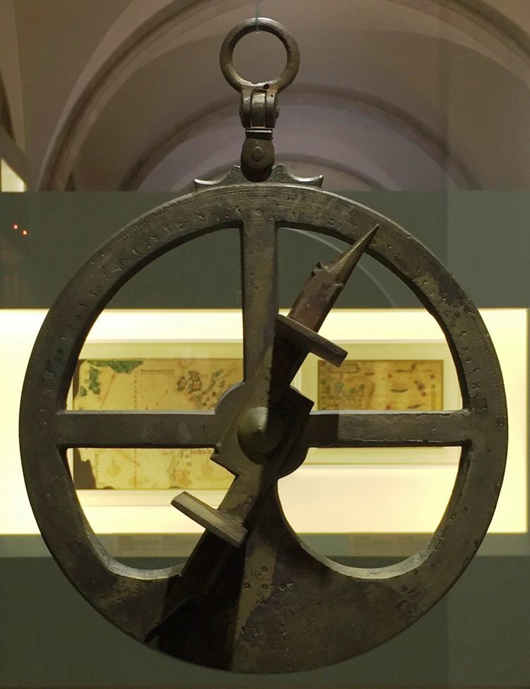
The astrolabe (meaning to “take a star”) was one of the most useful navigational tools in ancient times. Initially made an astronomical tool, the astrolabe later became “the mariner’s astrolabe” as sailors found a use for it. It typically comes in spherical or quadrant shapes.
The astrolabe, an inclinometer, helped sailors determine their ships’ latitudes by measuring the sun’s altitude and angles. While astrolabes made accurate readings, they required clear weather to function properly.
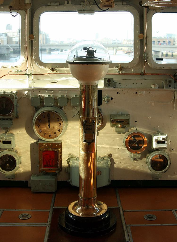
2. Compass
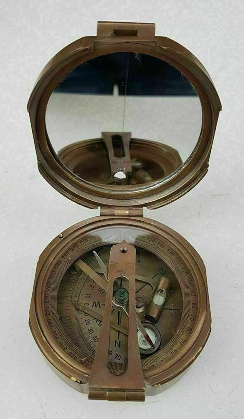
We’re sure you already know this tool— the circular north-pointing object with a dial and magnetic needle. However, it’s interesting to note that compasses weren’t always perfectly spherical. In the beginning, they had the spoons.
They’re arguably the most popular antique navigation tools today. The compass was one of the most reliable navigation tools for finding direction.
You will learn all you need to know about compasses in this video. Submarines still use the compass to date.
3. Cross-Staffs/ Jacob’s Staff
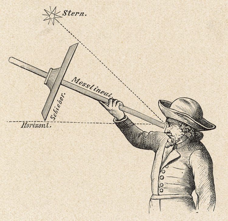
Cross-staffs looked like a staff with one long and one short sliding wooden cross piece at both ends. Sailors used them to measure the distance between Polaris and the horizon by holding the staff’s base to their eye.
Then, they slid the transversal to the far end in forth and back movements. They did that till the bottom and the top aligned with the horizon and the sun or a star.
Cross-staffs are also called Jacob’s staff in reference to Jacob using a staff to cross the River Jordan in the Bible.
4. Davis Quadrant/Back-Staff
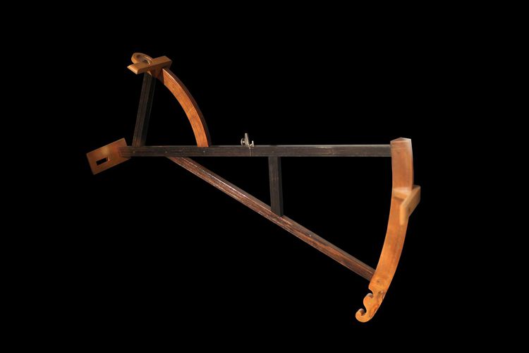
John Davis, an English Captain, invented the back-staff in the 1590s as a safer alternative to the cross-staff. Sailors using the cross-staff had to look directly at the sun to measure its height. That puts them at risk of blindness.
With the back-staff or Davis quadrant, however, the sailors faced their backs to the sun. The user-determined the sun’s latitude through its reflection of the back-staff’s horizontal slit and by adjusting the sliding vane.
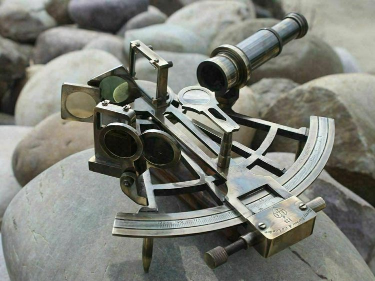
5. The Sextant
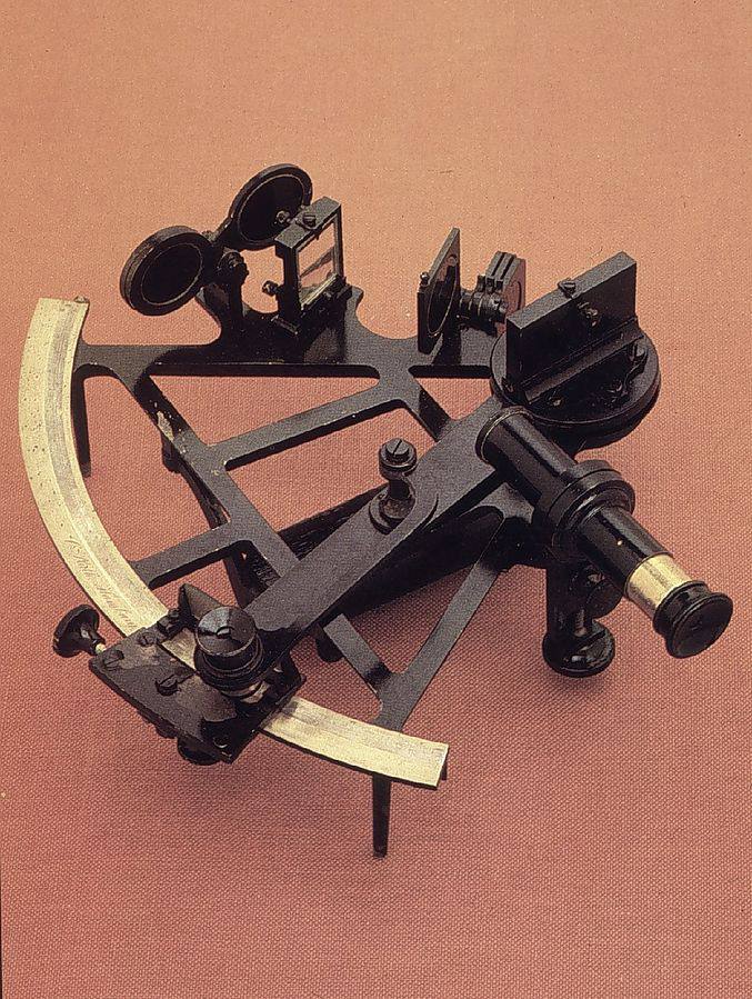
Thomas Godfrey of Philadelphia and John Hadley of England invented the sextant independently in the 18th century. It was used to measure the distance between two visible objects. Sailors also used it to keep track of their voyages.
It was an effective navigational tool for measuring longitudes and latitudes. They’re still in use in planes and ships today.
6. Lead Line
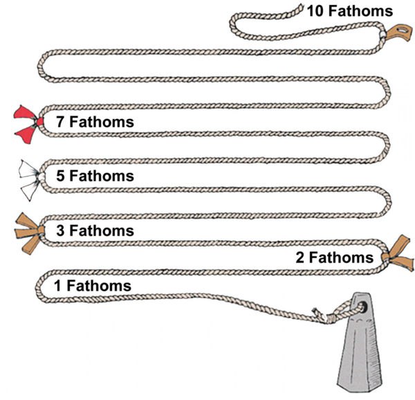
Lead lines, one of the oldest navigational tools, allow sailors to measure water depth. In use as far back as the 5th century BC, lead lines also obtain a sample of the ocean floor. This instrument comprised a hand-held reel, a hollow lead weight of about 20 pounds, and a long rope.
According to ThePirateKing.Com, a glob of animal fat was inserted at the bottom of the lead weight. As the fat glob hit the ocean floor, the material stuck to it. The material helped to determine their location on the sea. When the sailors retrieve the line, they can tell the sea’s depth by its markings.
7. The Sandglass and Chip Logs
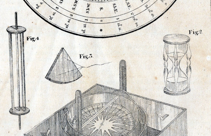
The sandglass (also hourglass) was used to measure time and typically came in four-hour and half-hour sizes. It had two glass bulbs and a narrow neck between them.
One glass was filled with rocks or marbles and measured time intervals as the rocks trickled into the other glass. When all the rocks had run through, a ship-boy announced the time, inverted the bulbs, and continued the process.
Chip logs were speedometers that were used together with the sandglasses. They comprised a large rope spool with knots along its length.
8. Pelorus
The pelorus is a round instrument that looks like a compass but, unlike it, doesn’t have a directive element. By remaining at 000° on the lubber’s line, it helps to measure and observe relative bearings of other ships. Sailors can use the pelorus to verify that they’re traveling in forward direction.
Today, this antique navigational tool is still useful for measuring the distance between boats. It helps to avoid collisions.
9. Telescope
Telescopes or spy glasses are common antique navigational tools that were invented in 1608 by Hans Lipperhey, an eyeglass maker, to view planets. Seafarers used it to spot landfalls and distant ships.
This was particularly useful in sighting pirate ships and enemy vessels afar off. It also helped mariners to avoid navigation hazards.
Telescopes were typically made from brass, wood, and glass.
10. Navigational Map & Nautical Chart
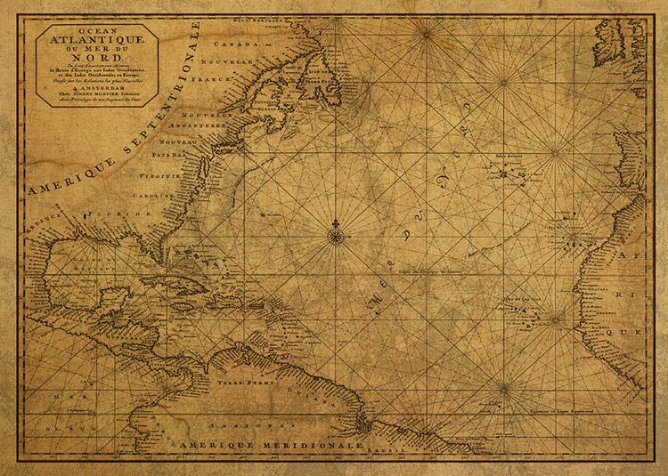
Antique nautical charts and maps were essential tools of safe navigation and voyage planning for sailors. The National Ocean Service describes the nautical charts as “a map that depicts the configuration of the shoreline and seafloor.”
Navigational maps and charts are still in use today. They help mariners recognize specific hazards on a route beforehand.
The Best Places to Purchase Vintage Navigational Tools
If you want to purchase antique navigational tools over the internet, you can consider using the following online platforms:
● eBay
You can find numerous vintage navigational tools on eBay for excellent prices. For example, these marine navigation tools in a box comprise a telescope, magnifier glass, and compass, all for $60. You can find better offers and close better deals as you scroll through the website.
● Amazon
Apart from Amazon’s great prices, you can take advantage of their vast selections. Amazon has almost any antique navigational tool you may want. Many of them come in good condition too.
The antique maritime nautical ship sextant is one of our favorite pieces on Amazon. You can use this sextant for basic measurements, and it comes with a wooden keyring gift.
● Land and Sea Collection
Joel and Julie Jacobs founded Land and Sea Collection in 2003 as a source for premium and interesting navigational antiques. So far, they’ve lived up to our expectations.
If you prioritize quality antique navigational tools that offer value for money, check out the items on their website. We’re particularly in love with this British admiralty telescope and “Officer of the Deck” U.S Navy telescope of the mid-1800s. Land and Sea Collections ships overseas.
● Etsy
Etsy is a great and reliable online marketplace for antique navigational tools. The site is user-friendly, and you can be sure of the best prices.
Check out this sextant from Etsy.
Conclusion
Antique navigational tools are great items for a vintage collection. Understanding how useful they are even today will help you appreciate their value. You can use them to determine your location and direction when there’s no GPS—how’s that for fabulous?
We’d like to know what you think about antique navigational tools and what they mean to you. Are you getting any, and which of them are your favorites?
Drop your questions in the comments too. We’ll respond to you in an instant.


![Vintage Schwinn Bikes: [Types, Identification, and Values]](https://www.txantiquemall.com/wp-content/uploads/2022/05/5.-Schwinn-1967-Ramshorn-Fastback-Stingray-Sky-Blue-vtg-600x450.jpg)